|
History
Native American inhabitation
Some of the oldest stone tools found in Minnesota. The oldest known human remains in Minnesota, dating back about 9000 years ago, were discovered near Browns Valley in 1933. "Browns Valley Man" was found with tools of the Clovis and Folsom types. Some of the earliest evidence of a sustained presence in the area comes from a site known as Bradbury Brook near Mille Lacs Lake which was used around 7500 BC. Subsequently, extensive trading networks developed in the region. The body of an early resident known as "Minnesota Woman" was discovered in 1931 in Otter Tail County. Radiocarbon dating places the age of the bones approximately 8,000 years ago, near the end of the Eastern Archaic period. She had a conch shell from a snail species known as Busycon perversa, which had previously only been known to exist in Florida.
|
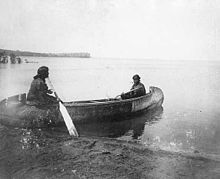
Ojibwa women in canoe, Leech Lake, 1909
|
Several hundred years later, the climate of Minnesota warmed significantly. As large animals such as mammoths became extinct, native people changed their diet. They gathered nuts, berries, and vegetables, and they hunted smaller animals such as deer, bison, and birds. The stone tools found from this era became smaller and more specialized to use these new food sources. They also devised new techniques for catching fish, such as fish hooks, nets, and harpoons. Around 5000 BC, people on the shores of Lake Superior (in Minnesota and portions of what is now Michigan, Wisconsin, and Canada) were the first on the continent to begin making metal tools. Pieces of ore with high concentrations of copper were initially pounded into a rough shape, heated to reduce brittleness, pounded again to refine the shape, and reheated. Edges could be made sharp enough to be useful as knives or spear points. Archaeological evidence of Native American settlements dates back as far as 3000 BC; the Jeffers Petroglyphs site in southwest Minnesota contains carvings thought to date to the Late Archaic Period (3000 BC to 1000 BC). Around 700 BC, burial mounds were first created, and the practice continued until the arrival of Europeans, when 10,000 such mounds dotted the state. By AD 800, wild rice became a staple crop in the region, and corn farther to the south. Within a few hundred years, the Mississippian culture reached into the southeast portion of the state, and large villages were formed. The Dakota Native American culture may have descended from some of the peoples of the Mississippian culture. When Europeans first started exploring Minnesota, the region was inhabited primarily by tribes of Dakota, with the Ojibwa (sometimes called Chippewa, or Anishinaabe) beginning to migrate westward into the state around 1700. (Other sources suggest the Ojibwe reached Minnesota by 1620 or earlier.) There were also the Chiwere Ioway in the southwest, the Algonquian A'ani to the west, and possibly the Menominee in some parts of the southeast as well as other tribes which could have been either Algonquian or Chiwere to the northeast, alongside Lake Superior (possibilities include the Fauk, Sauk, and Missouria). The economy of these tribes was chiefly based on hunter-gatherer activities. There was also a small group of Ho-Chunk (Winnebago) Native Americans near Long Prairie, who later moved to a reservation in Blue Earth County in 1855. At some early point, the Missouria moved south into what is now Missouri, the Menominee ceded much of their westernmost lands and withdrew closer to the region of Green Bay, Wisconsin, and the A'ani were pushed north and west by the Dakota and split into the Gros Ventre and the Arapaho. Later tribes who would inhabit the region include the Assiniboine, who split from the Dakota and returned to Minnesota, but later also moved west as American settlers came to populate the region.
|
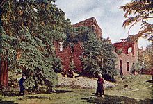
Ruins of old Fond du Lac trading post on the Saint Louis River in 1907
|
European exploration
In the late 1650s, Pierre Esprit Radisson and Médard des Groseilliers were likely the first Europeans to meet Dakota Native Americans while following the southern shore of Lake Superior (which would become northern Wisconsin). The north shore was explored in the 1660s. Among the first to do this was Claude Allouez, a missionary on Madeline Island. He made an early map of the area in 1671. Around this time, the Ojibwa Native Americans reached Minnesota as part of a westward migration. Having come from a region around Maine, they were experienced at dealing with European traders. They dealt in furs and possessed guns. Tensions rose between the Ojibwa and Dakota in the ensuing years. In 1671, France signed a treaty with a number of tribes to allow trade. Shortly thereafter, French trader Daniel Greysolon, Sieur du Lhut arrived in the area and began trading with the local tribes. Du Lhut explored the western area of Lake Superior, near his namesake, the city of Duluth, and areas south of there. He helped to arrange a peace agreement between the Dakota and Ojibwa tribes in 1679.
|
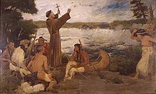
A painting of Father Hennepin 'discovering' Saint Anthony Falls.
|
Father Louis Hennepin with companions Michel Aco and Antoine Auguelle (aka Picard Du Gay) headed north from the area of Illinois after coming into that area with an exploration party headed by René-Robert Cavelier, Sieur de La Salle. They were captured by a Dakota tribe in 1680. While with the tribe, they came across and named the Falls of Saint Anthony. Soon, Du Lhut negotiated to have Hennepin's party released from captivity. Hennepin returned to Europe and wrote a book, Description of Louisiana, published in 1683, about his travels where many portions (including the part about Saint Anthony Falls) were strongly embellished. As an example, he described the falls as being a drop of fifty or sixty feet, when they were really only about sixteen feet. Pierre-Charles Le Sueur explored the Minnesota River to the Blue Earth area around 1700. He thought the blue earth was a source of copper, and he told stories about the possibility of mineral wealth, but there actually was no copper to be found. Explorers searching for the fabled Northwest Passage and large inland seas in North America continued to pass through the state. In 1721, the French built Fort Beauharnois on Lake Pepin. In 1731, the Grand Portage trail was first traversed by a European, Pierre La Vérendrye. He used a map written down on a piece of birch bark by Ochagach, an Assiniboine guide. The North West Company, which traded in fur and competed with the Hudson's Bay Company, was established along the Grand Portage in 1783-1784. Jonathan Carver, a shoemaker from Massachusetts, visited the area in 1767 as part of another expedition. He and the rest of the exploration party were only able to stay for a relatively short period, due to supply shortages. They headed back east to Fort Michilimackinac, where Carver wrote journals about the trip, though others would later claim the stories were largely plagiarized from others. The stories were published in 1778, but Carver died before the book earned him much money. Carver County and Carver's Cave are named for him.
Until 1818 the Red River Valley was considered British and was subject to several colonization schemes, such as the Red River Colony. The boundary where the Red River crossed the 49th parallel was not marked until 1823, when Stephen H. Long conducted a survey expedition. When several hundred settlers abandoned the Red River Colony in the 1820s, they entered the United States by way of the Red River Valley, instead of moving to eastern Canada or returning to Europe. The region had been occupied by Métis people, the children of voyageurs and Native Americans, since the middle 17th century. Several efforts were made to determine the source of the Mississippi River. The true source was found in 1832, when Henry Schoolcraft was guided by a group of Ojibwa headed by Ozaawindib ("Yellow Head") to a lake in northern Minnesota. Schoolcraft named it Lake Itasca, combining the Latin words veritas ("truth") and caput ("head"). The native name for the lake was Omashkooz, meaning elk. Other explorers of the area include Zebulon Pike in 1806, Major Stephen Long in 1817, George William Featherstonhaugh in 1835, and John Pope (military officer) in 1849. Featherstonhaugh conducted a geological survey of the Minnesota River valley and wrote an account entitled A Canoe Voyage up the Minnay Sotor. Joseph Nicollet scouted the area in the late 1830s, exploring and mapping the Upper Mississippi River basin, the St. Croix River, and the land between the Mississippi and Missouri Rivers. He and John C. Frémont left their mark in the southwest of the state, carving their names in the pipestone quarries near Winnewissa Falls (an area now part of Pipestone National Monument in Pipestone County). Henry Wadsworth Longfellow never explored the state, but he did help to make it popular. He published The Song of Hiawatha in 1855, which contains references to many regions in Minnesota. The story was based on Ojibwa legends carried back east by other explorers and traders (particularly those collected by Henry Rowe Schoolcraft).
All
of the land east of the Mississippi River was
granted to the United States by the Second Treaty
of Paris at the end of the American Revolution in
1783. This included what would become modern day
Saint Paul but only part of Minneapolis, including
the northeast, north-central and east-central
portions of the state. The western portion of the
state was part of the Spanish Louisiana since the
Treaty of Fontainebleau, in 1762. The wording of
the treaty in the Minnesota area depended on
landmarks reported by fur traders, who erroneously
reported an "Isle Phelipeaux" in Lake Superior, a
"Long Lake" west of the island, and the belief
that the Mississippi River ran well into modern
Canada. Most of the state was purchased in 1803
from France as part of the Louisiana Purchase.
Parts of northern Minnesota were considered to be
in Rupert's Land. The exact definition of the
boundary between Minnesota and British North
America was not addressed until the Anglo-American
Convention of 1818, which set the U.S.-Canada
border at the 49th parallel west of the Lake of
the Woods (except for a small chunk of land now
dubbed the Northwest Angle). Border disputes east
of the Lake of the Woods continued until the
Webster-Ashburton Treaty of 1842. Throughout the
first half of the 19th century, the northeastern
portion of the state was a part of the Northwest
Territory, then the Illinois Territory, then the
Michigan Territory, and finally the Wisconsin
Territory. The western and southern areas of the
state, although theoretically part of the
Wisconsin Territory from its creation in 1836,
were not formally organized until 1838, when they
became part of the Iowa Territory.
|
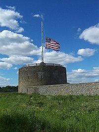
Fort
Snelling |
Fort
Snelling was the first major U.S. military
presence in the state. The land for the fort, at
the confluence of the Minnesota and Mississippi
rivers, was acquired in 1805 by Zebulon Pike. When
concerns mounted about the fur trade in the area,
construction of the fort began in 1819.
Construction was completed in 1825, and Colonel
Josiah Snelling and his officers and soldiers left
their imprint on the area. One of the missions of
the fort was to mediate disputes between the
Ojibwe and the Dakota tribes. Lawrence Taliaferro
was an agent of the U.S. Bureau of Indian Affairs.
He spent 20 years at the site, finally resigning
in 1839.
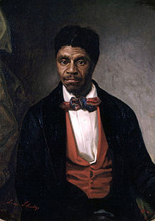 In the 1850s, Fort Snelling
played a key role in the infamous Dred Scott court
case. Slaves Dred Scott and his wife were taken to
the fort by their master, John Emerson. They lived
at the fort and elsewhere in territories where
slavery was prohibited. After Emerson's death, the
Scotts argued that since they had lived in free
territory, they were no longer slaves. Ultimately,
the U.S. Supreme Court sided against the Scotts.
Dred Scott Field, located just a short distance
away in Bloomington, is named in the memory of
Fort Snelling's significance in one of the most
important legal precedents in U.S. History. By
1851, treaties between Native American tribes and
the U.S. government had opened much of Minnesota
to settlement, so Fort Snelling no longer was a
frontier outpost. It served as a training center
for soldiers during the American Civil War and
later as the headquarters for the Department of
Dakota. A portion has been designated as Fort
Snelling National Cemetery where over 160,000 are
interred. During World War II, the fort served as
a training center for nearly 300,000 inductees.
After World War II, the fort was threatened with
demolition due to the building of freeways Highway
5 and Highway 55, but citizens rallied to save it.
Fort Snelling is now a historic site operated by
the Minnesota Historical Society. Fort Snelling
was largely responsible for the establishment of
the city of Minneapolis. In an effort to be
self-sufficient, the soldiers of the fort built
roads, planted crops, and built a grist mill and a
sawmill at Saint Anthony Falls. Later, Franklin
Steele came to Fort Snelling as the post sutler
(the operator of the general store), and
established interests in lumbering and other
activities. When the Ojibwe signed a treaty ceding
lands in 1837, Steele staked a claim to land on
the east side of the Mississippi River adjacent to
Saint Anthony Falls. In 1848, he built a sawmill
at the falls, and the community of Saint Anthony
sprung up around the east side of the falls.
Steele told one of his employees, John H. Stevens,
that land on the west side of the falls would make
a good site for future mills. Since the land on
the west side was still part of the military
reservation, Stevens made a deal with Fort
Snelling's commander. Stevens would provide free
ferry service across the river in exchange for a
tract of 160 acres (0.65 km2) at the head of the
falls. Stevens received the claim and built a
house, the first house in Minneapolis, in 1850. In
1854, Stevens platted the city of Minneapolis on
the west bank. Later, in 1872, Minneapolis
absorbed the city of Saint Anthony. The city of
Saint Paul, Minnesota owes its existence to Fort
Snelling. A group of squatters, mostly from the
ill-fated Red River Colony in what is now the
Canadian province of Manitoba, established a camp
near the fort. The commandant of Fort Snelling,
Major Joseph Plympton, found their presence
problematic because they were using timber and
allowing their cattle and horses to graze around
the fort. Plympton banned lumbering and the
construction of any new buildings on the military
reservation land. As a result, the squatters moved
four miles downstream on the Mississippi River.
They settled at a site known as Fountain Cave.
This site was not quite far enough for the
officers at the fort, so the squatters were forced
out again. Pierre "Pig's Eye" Parrant, a popular
moonshiner among the group, moved downriver and
established a saloon, becoming the first European
resident in the area that later became Saint Paul.
The squatters named their settlement "Pig's Eye"
after Parrant. The name was later changed to
Lambert's Landing and then finally Saint Paul.
However, the earliest name for the area comes from
a Native American colony Im-in-i-ja Ska, meaning
"White Rock" and referring to the limestone bluffs
nearby. In the 1850s, Fort Snelling
played a key role in the infamous Dred Scott court
case. Slaves Dred Scott and his wife were taken to
the fort by their master, John Emerson. They lived
at the fort and elsewhere in territories where
slavery was prohibited. After Emerson's death, the
Scotts argued that since they had lived in free
territory, they were no longer slaves. Ultimately,
the U.S. Supreme Court sided against the Scotts.
Dred Scott Field, located just a short distance
away in Bloomington, is named in the memory of
Fort Snelling's significance in one of the most
important legal precedents in U.S. History. By
1851, treaties between Native American tribes and
the U.S. government had opened much of Minnesota
to settlement, so Fort Snelling no longer was a
frontier outpost. It served as a training center
for soldiers during the American Civil War and
later as the headquarters for the Department of
Dakota. A portion has been designated as Fort
Snelling National Cemetery where over 160,000 are
interred. During World War II, the fort served as
a training center for nearly 300,000 inductees.
After World War II, the fort was threatened with
demolition due to the building of freeways Highway
5 and Highway 55, but citizens rallied to save it.
Fort Snelling is now a historic site operated by
the Minnesota Historical Society. Fort Snelling
was largely responsible for the establishment of
the city of Minneapolis. In an effort to be
self-sufficient, the soldiers of the fort built
roads, planted crops, and built a grist mill and a
sawmill at Saint Anthony Falls. Later, Franklin
Steele came to Fort Snelling as the post sutler
(the operator of the general store), and
established interests in lumbering and other
activities. When the Ojibwe signed a treaty ceding
lands in 1837, Steele staked a claim to land on
the east side of the Mississippi River adjacent to
Saint Anthony Falls. In 1848, he built a sawmill
at the falls, and the community of Saint Anthony
sprung up around the east side of the falls.
Steele told one of his employees, John H. Stevens,
that land on the west side of the falls would make
a good site for future mills. Since the land on
the west side was still part of the military
reservation, Stevens made a deal with Fort
Snelling's commander. Stevens would provide free
ferry service across the river in exchange for a
tract of 160 acres (0.65 km2) at the head of the
falls. Stevens received the claim and built a
house, the first house in Minneapolis, in 1850. In
1854, Stevens platted the city of Minneapolis on
the west bank. Later, in 1872, Minneapolis
absorbed the city of Saint Anthony. The city of
Saint Paul, Minnesota owes its existence to Fort
Snelling. A group of squatters, mostly from the
ill-fated Red River Colony in what is now the
Canadian province of Manitoba, established a camp
near the fort. The commandant of Fort Snelling,
Major Joseph Plympton, found their presence
problematic because they were using timber and
allowing their cattle and horses to graze around
the fort. Plympton banned lumbering and the
construction of any new buildings on the military
reservation land. As a result, the squatters moved
four miles downstream on the Mississippi River.
They settled at a site known as Fountain Cave.
This site was not quite far enough for the
officers at the fort, so the squatters were forced
out again. Pierre "Pig's Eye" Parrant, a popular
moonshiner among the group, moved downriver and
established a saloon, becoming the first European
resident in the area that later became Saint Paul.
The squatters named their settlement "Pig's Eye"
after Parrant. The name was later changed to
Lambert's Landing and then finally Saint Paul.
However, the earliest name for the area comes from
a Native American colony Im-in-i-ja Ska, meaning
"White Rock" and referring to the limestone bluffs
nearby.
Minneapolis and Saint Paul
are collectively known as the "Twin Cities". The
cities enjoyed a rivalry during their early years,
with Saint Paul being the capital city and
Minneapolis becoming prominent through industry.
The term "Twin Cities" was coined around 1872,
after a newspaper editorial suggested that
Minneapolis could absorb Saint Paul. Residents
decided that the cities needed a separate
identity, so people coined the phrase "Dual
Cities", which later evolved into "Twin Cities".
Today, Minneapolis is the largest city in
Minnesota, with a population of 382,618 in the
2000 census. Saint Paul is the second largest
city, with a population of 287,151. Minneapolis
and Saint Paul anchor a metropolitan area with a
population of 2,968,806 as of 2000, with a total
state population of 4,919,479.
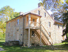 Home of
Henry Hastings Sibley Home of
Henry Hastings Sibley
Henry Hastings Sibley built
the first stone house in the Minnesota Territory
in Mendota in 1838, along with other limestone
buildings used by the American Fur Company, which
bought animal pelts at that location from 1825 to
1853.[51] Another area of early economic
development in Minnesota was the logging industry.
Loggers found the white pine especially valuable,
and it was plentiful in the northeastern section
of the state and in the St. Croix River valley.
Before railroads, lumbermen relied mostly on river
transportation to bring logs to market, which made
Minnesota's timber resources attractive. Towns
like Marine on St. Croix and Stillwater became
important lumber centers fed by the St. Croix
River, while Winona was supplied lumber by areas
in southern Minnesota and along the Minnesota
River. The unregulated logging practices of the
time and a severe drought took their toll in 1894,
when the Great Hinckley Fire ravaged 480 square
miles in the Hinckley and Sandstone areas of Pine
County, killing over 400 residents. The
combination of logging and drought struck again in
the Baudette Fire of 1910 and the Cloquet Fire of
1918.
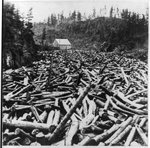 Logging pine 1860's-1870's Logging pine 1860's-1870's
Saint Anthony, on the east
bank of the Mississippi River later became part of
Minneapolis, and was an important lumber milling
center supplied by the Rum River. In 1848,
businessman Franklin Steele built the first
private sawmill on the Saint Anthony Falls, and
more sawmills quickly followed. The oldest home
still standing in Saint Anthony is the Ard Godfrey
house, built in 1848, and lived in by Ard and
Harriet Godfrey. The house of John H. Stevens, the
first house on the west bank in Minneapolis, was
moved several times, finally to Minnehaha Park in
south Minneapolis in 1896.
Minnesota
Territory
Stephen A. Douglas (D), the
chair of the Senate Committee on Territories,
drafted the bill authorizing Minnesota Territory.
He had envisioned a future for the upper
Mississippi valley, so he was motivated to keep
the area from being carved up by neighboring
territories. In 1846, he prevented Iowa from
including Fort Snelling and Saint Anthony Falls
within its northern border. In 1847, he kept the
organizers of Wisconsin from including Saint Paul
and Saint Anthony Falls. The Minnesota Territory
was established from the lands remaining from Iowa
Territory and Wisconsin Territory on March 3,
1849. The Minnesota Territory extended far into
what is now North Dakota and South Dakota, to the
Missouri River. There was a dispute over the shape
of the state to be carved out of Minnesota
Territory. An alternate proposal that was only
narrowly defeated would have made the 46th
parallel the state's northern border and the
Missouri River its western border, thus giving up
the whole northern half of the state in exchange
for the eastern half of what later became South
Dakota. With Alexander Ramsey (W) as the first
governor of Minnesota Territory and Henry Hastings
Sibley (D) as the territorial delegate to the
United States Congress, the populations of Saint
Paul and Saint Anthony swelled. Henry M. Rice (D),
who replaced Sibley as the territorial delegate in
1853, worked in Congress to promote Minnesota
interests. He lobbied for the construction of a
railroad connecting Saint Paul and Lake Superior,
with a link from Saint Paul to the Illinois
Central.
Statehood
In December 1856, Rice
brought forward two bills in Congress: an enabling
act that would allow Minnesota to form a state
constitution, and a railroad land grant bill.
Rice's enabling act defined a state containing
both prairie and forest lands. The state was
bounded on the south by Iowa, on the east by
Wisconsin, on the north by Canada, and on the west
by the Red River of the North and the Bois de
Sioux River, Lake Traverse, Big Stone Lake, and
then a line extending due south to the Iowa
border. Rice made this motion based on Minnesota's
population growth. At the time, tensions between
the northern and the southern United States were
growing, in a series of conflicts that eventually
resulted in the American Civil War. There was
little debate in the United States House of
Representatives, but when Stephen A. Douglas
introduced the bill in the United States Senate,
it caused a firestorm of debate. Northerners saw
their chance to add two senators to the side of
the free states, while Southerners were sure that
they would lose power. Many senators offered
polite arguments that the population was too
sparse and that statehood was premature. Senator
John Burton Thompson of Kentucky, in particular,
argued that new states would cost the government
too much for roads, canals, forts, and
lighthouses. Although Thompson and 21 other
senators voted against statehood, the enabling act
was passed on February 26, 1857. After the
enabling act was passed, territorial legislators
had a difficult time writing a state constitution.
A constitutional convention was assembled in July
1857, but Republicans and Democrats were deeply
divided. In fact, they formed two separate
constitutional conventions and drafted two
separate constitutions. Eventually, the two groups
formed a conference committee and worked out a
common constitution. The divisions continued,
though, because Republicans refused to sign a
document that had Democratic signatures on it, and
vice versa. One copy of the constitution was
written on white paper and signed only by
Republicans, while the other copy was written on
blue-tinged paper and signed by Democrats. These
copies were signed on August 29, 1857. An election
was called on October 13, 1857, where Minnesota
residents would vote to approve or disapprove the
constitution. The constitution was approved by
30,055 voters, while 571 rejected it. The state
constitution was sent to the United States
Congress for ratification in December 1857. The
approval process was drawn out for several months
while Congress debated over issues that had
stemmed from the Kansas-Nebraska Act. Southerners
had been arguing that the next state should be
pro-slavery, so when Kansas submitted the
pro-slavery Lecompton Constitution, the Minnesota
statehood bill was delayed. After that,
Northerners feared that Minnesota's Democratic
delegation would support slavery in Kansas.
Finally, after the Kansas question was settled and
after Congress decided how many representatives
Minnesota would get in the House of
Representatives, the bill passed. The eastern half
of the Minnesota Territory, under the boundaries
defined by Henry Mower Rice, became the country's
32nd state on May 11, 1858. The western part
remained unorganized until its incorporation into
the Dakota Territory on March 2,
1861.
Civil
War era and Dakota War of 1862
Minnesota strongly supported
the Union war effort, with about 22,000
Minnesotans serving. The 1st Minnesota Volunteer
Infantry was particularly important to the Battle
of Gettysburg. Governor Alexander Ramsey happened
to be in Washington D.C. when Ft. Sumter was fired
upon. He went immediately to the White House and
made his state the first to offer help in putting
down the rebellion. At the same time, the state
faced another crisis as the Dakota War of 1862
broke out. The Dakota had signed the Treaty of
Traverse des Sioux and Treaty of Mendota in 1851
because they were concerned that without money
from the United States government, they would
starve, due to the loss of habitat of huntable
game. They were initially given a strip of land of
ten miles north and south of the Minnesota River,
but they were later forced to sell the northern
half of the land. In 1862, crop failures left the
Dakota with food shortages, and government money
was delayed. After four young Dakota men,
searching for food, shot a family of white
settlers near Acton, the Dakota leadership decided
to continue the attacks in an effort to drive out
the settlers. Over a period of several days,
Dakota attacks at the Lower Sioux Agency, New Ulm
and Hutchinson, as well as in the surrounding
farmlands, resulted in the deaths of at least 300
to 400 white settlers and government employees,
causing panic in the settlements and provoking
counterattacks by state militia and federal forces
which spread throughout the Minnesota River Valley
and as far away as the Red River Valley. The
ensuing battles at Fort Ridgely, Birch Coulee,
Fort Abercrombie, and Wood Lake punctuated a
six-week war, which ended with the trial of 425
Native Americans for their participation in the
war. Of this number, 303 men were convicted and
sentenced to death.
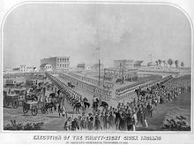 Mass
hanging in Mankato, Minnesota. Mass
hanging in Mankato, Minnesota.
Episcopal Bishop Henry
Benjamin Whipple pleaded to President Abraham
Lincoln for clemency, and the death sentences of
all but 39 men were reduced to prison terms. On
December 26, 1862, 38 men were hanged by the U.S.
Army at Mankato-the largest mass execution in the
United States. Many of the remaining Dakota Native
Americans, including non-combatants, were confined
in a prison camp at Pike Island over the winter of
1862-1863, where more than 300 died of disease.
Survivors were later exiled to the Crow Creek
Reservation, then later to a reservation near
Niobrara, Nebraska.
A
small number of Dakota Native Americans managed to
return to Minnesota in the 1880s and establish
communities near Granite Falls, Morton, Prior
Lake, and Red Wing. However, after this time
Dakota people were no longer allowed to reside in
Minnesota with the exception of the meritorious
Sioux called the Loyal Mdewakanton. This separate
class of Dakota did not participate in the Dakota
War of 1862, since they were assimilated
Christians and instead decided to help some of the
missionaries escape the Sioux warriors who chose
to fight.
Farming and railroad
development
After the
Civil War, Minnesota became an attractive region
for European immigration and settlement as
farmland. Minnesota's population in 1870 was
439,000; this number tripled during the two
subsequent decades. The Homestead Act in 1862
facilitated land claims by settlers, who regarded
the land as being cheap and fertile. The railroad
industry, led by the Northern Pacific Railway and
Saint Paul and Pacific Railroad, advertised the
many opportunities in the state and worked to get
immigrants to settle in Minnesota. James J. Hill,
in particular, was instrumental in reorganizing
the Saint Paul and Pacific Railroad and extending
lines from the Minneapolis-Saint Paul area into
the Red River Valley and to Winnipeg. Hill was
also responsible for building a new passenger
depot in Minneapolis, served by the landmark Stone
Arch Bridge which was completed in 1883. During
the 1880s, Hill continued building tracks through
North Dakota and Montana. In 1890, the railroad,
now known as the Great Northern Railway, started
building tracks through the mountains west to
Seattle. Other railroads, such as the Lake
Superior and Mississippi Railroad and the
Milwaukee Road, also played an important role in
the early days of Minnesota's statehood. Later
railways, such as the Soo Line and Minneapolis and
St. Louis Railway facilitated the sale of
Minneapolis flour and other products, although
they were not as involved in attracting
settlers.
Oliver Hudson Kelley played
an important role in farming as one of the
founders of the National Grange, along with
several other clerks in the United States
Department of Agriculture. The movement grew out
of his interest in cooperative farm associations
following the end of the Civil War, and he
established local Grange chapters in Elk River and
Saint Paul. The organization worked to provide
education on new farming methods, as well as to
influence government and public opinion on matters
important to farmers. One of these areas of
concern was the freight rates charged by the
railroads and by the grain elevators. Since there
was little or no competition between railroads
serving Minnesota farm communities, railroads
could charge as much as the traffic would bear. By
1871, the situation was so heated that both the
Republican and Democratic candidates in state
elections promised to regulate railroad rates. The
state established an office of railroad
commissioner and imposed maximum charges for
shipping. Populist Ignatius L. Donnelly also
served the Grange as an organizer. Saint Anthony
Falls, the only waterfall of its height on the
Mississippi, played an important part in the
development of Minneapolis. The power of the
waterfall first fueled sawmills, but later it was
tapped to serve flour mills. In 1870, only a small
number of flour mills were in the Minneapolis
area, but by 1900 Minnesota mills were grinding
14.1% of the nation's grain. Advances in
transportation, milling technology, and water
power combined to give Minneapolis a dominance in
the milling industry. Spring wheat could be sown
in the spring and harvested in late summer, but it
posed special problems for milling. To get around
these problems, Minneapolis millers made use of
new technology. They invented the middlings
purifier, a device that used jets of air to remove
the husks from the flour early in the milling
process. They also started using roller mills, as
opposed to grindstones. A series of rollers
gradually broke down the kernels and integrated
the gluten with the starch. These improvements led
to the production of "patent" flour, which
commanded almost double the price of "bakers" or
"clear" flour, which it replaced. Pillsbury and
the Washburn-Crosby Company (a forerunner of
General Mills) became the leaders in the
Minneapolis milling industry. This leadership in
milling later declined as milling was no longer
dependent on water power, but the dominance of the
mills contributed greatly to the economy of
Minneapolis and Minnesota, attracting people and
money to the region.
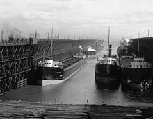 Industrial
development Industrial
development
Duluth, Missabe and Iron
Range Railway ore docks loading ships,
1900-1915.
At the end of
the 19th century, several forms of industrial
development shaped Minnesota. In 1882, a
hydroelectric power plant was built at Saint
Anthony Falls, marking one of the first
developments of hydroelectric power in the United
States.[76] Iron mining began in northern
Minnesota with the opening of the Soudan Mine in
1884. The Vermilion Range was surveyed and mapped
by a party financed by Charlemagne Tower. Another
mining town, Ely began with the foundation of the
Chandler Mine in 1888. Soon after, the Mesabi
Range was established when ore was found just
under the surface of the ground in Mountain Iron.
The Mesabi Range ultimately had much more ore than
the Vermilion Range, and it was easy to extract
because the ore was closer to the surface. As a
result, open-pit mines became well-established on
the Mesabi Range, with 111 mines operating by
1904. To ship the iron ore to refineries,
railroads such as the Duluth, Missabe and Iron
Range Railway were built from the iron ranges to
Two Harbors and Duluth on Lake Superior. Large ore
docks were used at these cities to load the iron
ore onto ships for transport east on the Great
Lakes. The mining industry helped to propel Duluth
from a small town to a large, thriving city. In
1904, iron was discovered in the Cuyuna Range in
Crow Wing County. Between 1904 and 1984, when
mining ceased, more than 106 million tons of ore
were mined. Iron from the Cuyuna Range also
contained significant proportions of manganese,
increasing its value.
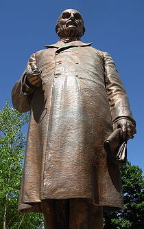 Mayo
Clinic Mayo
Clinic
Statue
of Dr. William Worrall Mayo near the Mayo Clinic
in Rochester
Dr. William
Worrall Mayo, the founder of the Mayo Clinic,
emigrated from Salford, United Kingdom to the
United States in 1846 and became a medical doctor
in 1850. In 1863, Mayo moved to Rochester,
followed by his family the next year. In the
summer of 1883, an F5 tornado struck, dubbed the
1883 Rochester tornado, causing a substantial
number of deaths and injuries. Dr. W. W. Mayo
worked with nuns from the Sisters of St. Francis
to treat the survivors. After the disaster, Mother
Alfred Moes and Dr. Mayo recognized the need for a
hospital and joined together to build the 27-bed
Saint Marys Hospital which opened in 1889. The
hospital, with over 1100 beds, is now part of the
Mayo Clinic, which grew out of the practice of
William Worrall Mayo and his sons, William James
Mayo (1861-1939) and Charles Horace Mayo. Dr.
Henry Stanley Plummer joined the Mayo Brothers'
practice in 1901. Plummer developed many of the
systems of group practice which are universal
around the world today in medicine and other
fields, such as a single medical record and an
interconnecting telephone system.
The information on Trails to
the Past © Copyright
may be used in personal family history research,
with source citation. The pages in entirety may
not be duplicated for publication in any fashion
without the permission of the owner. Commercial
use of any material on this site is not
permitted. Please respect the wishes of
those who have contributed their time and efforts
to make this free site possible.~Thank
you! |